A Practical Overview for Public Safety, Non-Critical-Infrastructure Commercial Entities, and Resilience Applications
This brief provides a practical overview of passive sensing technologies and how they can be applied across civilian and commercial settings. The intended audience spans Public Safety organizations and extends to commercial entities not traditionally classified as critical infrastructure: manufacturing plants, data centers, logistics hubs, corporate campuses, houses of worship, healthcare facilities, and public venues. These organizations face many of the same sensing challenges as utilities and airports, but often lack the budget, staff, or regulatory guidance that critical infrastructure operators receive.
The focus here is not military operations, offensive collection, or intrusive surveillance. It is safety, resilience, early warning, situational awareness, and responsible monitoring. Passive sensors support security teams, facility operators, emergency managers, and infrastructure owners by detecting anomalies, confirming events, and helping prioritizing response. One of the most important, and often hardest, parts of any project is finding practitioners who understand both the technology and the legal, operational, and privacy constraints around it.
Why Passive Sensing Matters
Modern facilities face a wider range of risks than traditional perimeter security was designed to handle. A county emergency manager, a mid-size manufacturer, a data center operator, or a regional transit authority may all need to detect unauthorized drone activity, unusual RF signatures, acoustic anomalies, or unexpected vehicle movement without a large security staff or a classified budget.
Passive sensing fills this gap by providing layered awareness without relying solely on cameras, guards, alarms, or active radar-like systems. Properly deployed, passive sensors help answer basic operational questions: What changed? Where did it happen? How confident are we? Is this isolated or part of a pattern? Should a person be alerted, another sensor be cued, or should the event simply be logged?
For Public Safety organizations, passive sensors support mission continuity and inter-agency coordination. For commercial entities outside traditional critical infrastructure, they provide an affordable and legally defensible path toward meaningful situational awareness.
Relevant Background and Perspective
My background includes co-inventing one of the first RF-based counter-drone systems in 2008. My work covers RF analysis, wireless systems, unmanned systems, counter-drone concepts, sensor fusion, and the practical limits of detection technologies, including some of the first drone detection systems deployed at civilian infrastructure: airports, shopping malls, prisons, borders, and conflict zones.
That experience has shaped a cautious view of passive sensing. These systems are powerful, but they are not magic. They work best when the customer clearly defines the environment, the threat or safety concern, available response options, and an acceptable false-alarm rate. Before choosing a vendor or buying equipment, define the actual operational question. The goal may be limited to detecting unauthorized vehicle movement after hours, identifying unusual RF activity near a facility, cueing cameras only when acoustic or RF conditions change, or monitoring a remote site without creating a large maintenance burden.
Major Categories of Passive Sensors
Remote ID Reception
Remote ID (RID) is the drone equivalent of a vehicle license plate. Under FAA regulations that took full effect in 2023, most commercial and recreational drones operating in the United States are required to broadcast identification and location information. Standard Remote ID uses two primary mechanisms: Bluetooth 5 (BLE) and Wi-Fi Neighbor Awareness Networking (Wi-Fi NAN), both in the 2.4 GHz band.
A passive RID receiver simply listens to compliant broadcasts and decodes the drone ID, takeoff location, current position, altitude, velocity, and operator location. A facility operator who sees an unknown drone ID approaching their perimeter with a logged takeoff location is in a far better position to assess risk and respond than one with no information at all.
The key caveat is that RID only covers compliant drones. Modified, foreign-manufactured, hobbyist, or deliberately non-compliant platforms may not broadcast. RID reception is most powerful when fused with other detection modalities rather than used alone. Several vendors now integrate RID into multi-sensor platforms with cellular backhaul for remote reporting to a common operating picture.
ADS-B Detection
Automatic Dependent Surveillance-Broadcast (ADS-B) is the transponder-based position reporting system used by manned aircraft. Aircraft equipped with ADS-B Out broadcast GPS-derived position, altitude, velocity, and identification on 978 and 1090 MHz. Passive ADS-B receivers can detect and display this traffic without any special licensing, and low-cost software-defined radio hardware can provide reception over 100 to 250 nautical miles under favorable conditions.
For facilities near airports, in Class B or C airspace, or along flight corridors, passive ADS-B awareness is operationally significant. A security team that can distinguish a compliant ADS-B-equipped aircraft from an unknown non-broadcasting drone has a clear advantage. ADS-B is also useful for documenting air traffic near a site for regulatory, insurance, or incident response purposes.
Passive RF Sensing Beyond RID and ADS-B
Passive RF sensors can monitor the broader radio-frequency environment beyond RID or ADS-B frequencies. They can detect, classify, and trend emissions from radios, mobile phones, Wi-Fi devices, telemetry links, industrial equipment, drones, and other electronic systems, helping identify unexpected transmitters, unusual communication patterns, interference events, or changes in the local spectrum environment.
**MavLink Emissions**
MavLink is an open-source lightweight messaging protocol widely used in commercial, prosumer, and open-source autopilot drone platforms, including ArduPilot and PX4. Communication between the flight controller and ground control station typically occurs over an unencrypted radio datalink on well-documented frequencies (typically 433 MHz, 868 MHz, 900 MHz, or 2.4/5.8 GHz).
A passive RF sensor may detect MavLink traffic patterns even without decoding content. Ground control stations can also be detected passively. A sensor identifying characteristic MavLink-related RF patterns has reasonable grounds to infer that an open-architecture drone is operating nearby, even without a compliant RID broadcast. This is a meaningful detection layer for facilities concerned about modified or custom-built platforms.
OcuSync and Proprietary Control Link Emissions
DJI's OcuSync is a proprietary video and control link system used across the DJI consumer and enterprise product line. OcuSync 2.0 and 3.0 operate in the 2.4 GHz and 5.8 GHz bands using frequency-hopping spread spectrum, making them more challenging to detect than fixed-frequency systems. However, the characteristic hopping patterns, signal bandwidth, and duty cycle of OcuSync transmissions are known to experienced RF analysts and to specialized drone-detection systems.
OcuSync detection does not require signal decoding or any interference with the drone. Passive detection of the control link emission is sufficient to indicate the presence of a DJI platform, which can then cue cameras, alert operators, or be fused with RID or acoustic data for higher-confidence characterization.
RF sensing can raise privacy, legal, and operational issues and should be handled carefully. Responsible deployments focus on metadata, spectrum activity, and anomaly detection rather than unnecessary collection of user content. Counter-drone RF sensing sits at the intersection of FAA authority, FCC spectrum regulations, and applicable federal and state laws governing radio monitoring.
Acoustic Sensors
Acoustic sensors detect and classify sounds including vehicles, machinery, breaking glass, drones, gunshots, and abnormal industrial noise. They are particularly useful where visual line-of-sight is limited or where cameras are legally or practically difficult to deploy. Every propeller-driven aircraft produces a characteristic acoustic signature based on motor speed, blade count, and airframe resonance, making acoustic sensing entirely passive and independent of whether the drone is broadcasting.
Modern acoustic drone detection systems use microphone arrays and machine learning classifiers to distinguish drone signatures from background noise: wind, traffic, birds, and HVAC equipment. Acoustic sensing typically has limited range (100 to 300 meters for small drones under reasonable noise conditions), but it is an excellent modality for cueing cameras or alerting operators when other sensors have already narrowed the search area. Good deployments require a baseline collection period and on-site tuning, since local noise conditions directly affect detection thresholds.
Passive Radar and Reflected-Signal Sensing
True passive radar systems detect objects by exploiting illumination from third-party broadcast sources -- FM radio, digital television, cellular base stations -- rather than emitting their own signal. A passive radar receiver correlates the direct-path signal with reflections of moving objects to extract range, velocity, and azimuth.
Passive radar is technically sophisticated and primarily found in research and specialized defense contexts today. Near-term civilian applications include detecting motion near fences and detecting low-altitude aircraft without emitting. Cost, complexity, and site-specific calibration requirements mean this modality requires careful scoping before deployment.
Optical and Infrared Sensors
Cameras, thermal imagers, and low-light sensors function as passive sensing nodes when used for event confirmation, anomaly detection, or cueing from other sensors. Thermal infrared is particularly valuable because it operates at night, in smoke, and in conditions that degrade visible cameras, and it reveals heat signatures from motors, exhaust, and electronics that would otherwise be invisible.
Seismic, Vibration, and Structural Sensors
Ground sensors, vibration sensors, and structural monitors detect movement, tampering, digging, vehicle passage, equipment stress, and abnormal vibration signatures. They are especially useful around pipelines, fences, substations, bridges, rail corridors, data center raised-floor environments, and remote infrastructure. Fiber-optic sensing cables buried along fence lines or pipelines can provide distributed sensing over kilometers with no active emission.
Detection, Tracking, and Identification: How It Comes Together
Detection, tracking, and identification are distinct operational tasks, and passive sensor systems address each of them differently.
Detection is recognizing that something is present or that something has changed. A single passive sensor can often perform detection reliably within its operational envelope. Detection is binary and relatively forgiving.
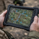
Tracking follows a detected object through time and space to build a trajectory or movement pattern. It requires either a sensor with spatial resolution or multiple sensors at known positions whose overlapping detections can be geometrically combined to estimate location. Fusing RID-derived position reports with RF bearing estimates and acoustic localization can produce a track with meaningful geographic accuracy. TAK integration allows that track to be shared with responding personnel in real time.
Identification determines what a detected and tracked object is. For compliant drones, RID provides the most direct path. For non-compliant platforms, identification relies on observable signatures. OcuSync emissions suggest a DJI platform. MavLink traffic patterns suggest ArduPilot or PX4. Acoustic signatures can indicate rotor count and approximate size class.
The Importance of Sensor Fusion
No single passive sensor should be treated as a complete solution. The real value comes from fusing multiple weak signals into a stronger operational picture. An acoustic anomaly plus an RF change plus a camera cue is far more useful than any one of those signals alone.
A well-designed system produces confidence-scored events rather than simple binary alarms. The output should help operators understand whether an event is likely benign, suspicious, urgent, or worth further review. Cellular backhaul enables this fusion to occur at a common operating picture level rather than requiring all sensors to be physically co-located.
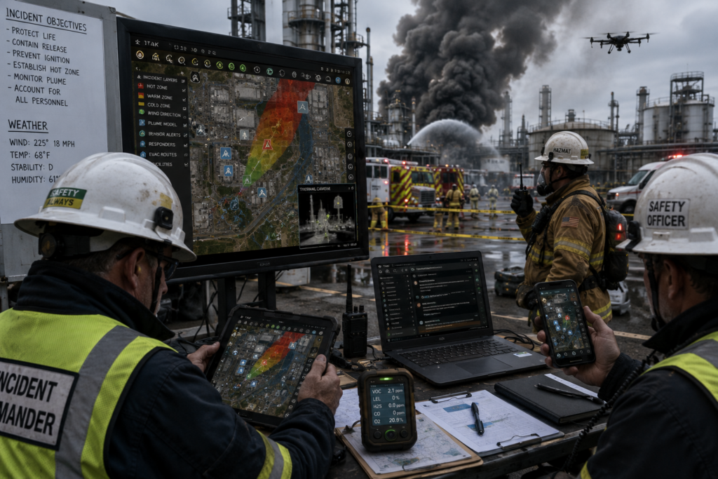
## Common Operating Picture and TAK
A Common Operating Picture (COP) is a single shared display where all relevant data -- sensor alerts, GPS tracks, video feeds, messages -- is presented on a geographic map so that every responding unit sees the same information at the same time.
The Team Awareness Kit (TAK) is the leading open-source COP platform, originally developed for the U.S. military and now widely adopted by law enforcement, fire and rescue, emergency management, and civilian security teams. TAK runs on Android (ATAK), iOS (iTAK), and Windows (WinTAK).
When passive RF sensor detects an unknown drone signature, that alert appears as a georeferenced icon on the shared map. If a second sensor -- acoustic or video -- corroborates the contact, the icon updates in real time. The resource nearest the location can see it on their device. No radio call is needed to relay coordinates. No one is working from a different picture. Response can be coordinated before anyone arrives on scene.
TAK ingests data from sensors using a standard format called Cursor on Target (CoT). Passive sensing vendors increasingly support CoT output, which means their detections can feed into a TAK environment with minimal integration work. TAK is free and open source, though the plugin landscape is large and uneven -- selecting the right integrations for a specific use case requires someone who knows which combinations work in the field.
Common Mistakes in Passive Sensor Projects
A common mistake is buying sensors before defining the operational problem. Another is assuming that a vendor demonstration will translate directly to the customer's site. Passive sensors are highly dependent on terrain, clutter, background noise, weather, infrastructure geometry, legal constraints, and available response procedures.
A third mistake is failing to define what happens after detection. Detection without a response path is often just noise. The customer should know whether an alert leads to human review, camera cueing, dispatch, logging, escalation, or integration with an existing security operations center.
A fourth mistake is assuming that RID compliance means all drones of concern will be detectable via RID alone. Responsible deployments layer RID with RF, acoustic, and optical sensors to cover both compliant and non-compliant platforms.
Recommended Project Approach
The best first step is a structured discovery process that identifies the site, the risks of concern, existing sensors and security procedures, legal and privacy boundaries, and the decision points the system must support.
A practical process:
1. Define the operational problem and the specific questions the system must answer.
2. Identify relevant passive sensing modalities based on the threat environment and site characteristics.
3. Map the physical and communications environment, including RF background, acoustic baselines, and existing infrastructure.
4. Establish baseline conditions through a structured observation period before setting thresholds or alarms.
5. Select candidate vendors based on fit to the operational problem, not marketing claims.
6. Conduct a limited pilot at a representative site with realistic evaluation criteria.
7. Measure performance against those criteria, including false positive and false negative rates.
8. Scale only after the customer understands the strengths, limits, and operational costs.
## How to Evaluate Vendors
Customers should look for vendors who can explain not only what their sensor detects but also what it does not detect. Strong vendors should be able to discuss false positives, false negatives, maintenance burden, data handling, integration paths, alert logic, environmental limits, and operator workflow.
Useful vendor questions:
- What specific problem is your system best at solving, and what are its known failure modes?
- What conditions cause false alarms, and how does the system handle ambiguous events?
- What data is collected, stored, and transmitted, and who has access to it?
- Can the system integrate with TAK, existing cameras, access control, or other security platforms?
- Does the system support cellular backhaul for remote or distributed deployments?
- How is detection confidence scored and communicated to the operator?
- What is required for installation, calibration, and ongoing maintenance?
- What evidence can you provide from comparable environments, threat types, and site conditions?
- How does your system handle privacy, legal constraints, and spectrum regulations?
- Does the system cover RID reception, ADS-B, MavLink signatures, OcuSync emissions, acoustic, camera, radar, or only some of these?
## Finding a Trusted Advisor
Passive sensing is a powerful tool, but only if applied correctly. The rules, regulations, vendor landscape, and practical integration realities make it difficult to deploy these tools legally and effectively without experienced guidance.
No single vendor covers the full picture, and most naturally frames every problem around what their own product addresses. That is why a trusted advisor who operates across vendors and modalities is so valuable.
For Public Safety agencies, houses of worship, manufacturing facilities, data centers, and other commercial entities evaluating passive sensing, the most important first step is not buying hardware. It is finding someone who can define the operational problem clearly, identify realistic sensor options, and separate credible vendor claims from marketing language.
For that, I recommend speaking with Zev Nadler of UAS Strategic. His portfolio spans the full passive detection chain: TAK integration for common operating picture display; cellular backhaul for remote sensor reporting; ADS-B detection for manned aircraft awareness; RID reception across Bluetooth and Wi-Fi NAN frequencies; and extended RF coverage adding MavLink and OcuSync detection to the same sensor stack.
If your organization is beginning to evaluate passive sensing, drone awareness, RF and acoustic detection, or related situational awareness technologies, speak with a trusted advisor early in the process.
---
NOTE: Add the sensor comparison table manually in WordPress using the Table block (click + > search Table). Columns: Modality | Primary Target | Environmental Resilience | Operational Dependency. Rows: Acoustic/Air Sonar, Radio Frequency, Electro-Optical/Thermal, Passive Radar.